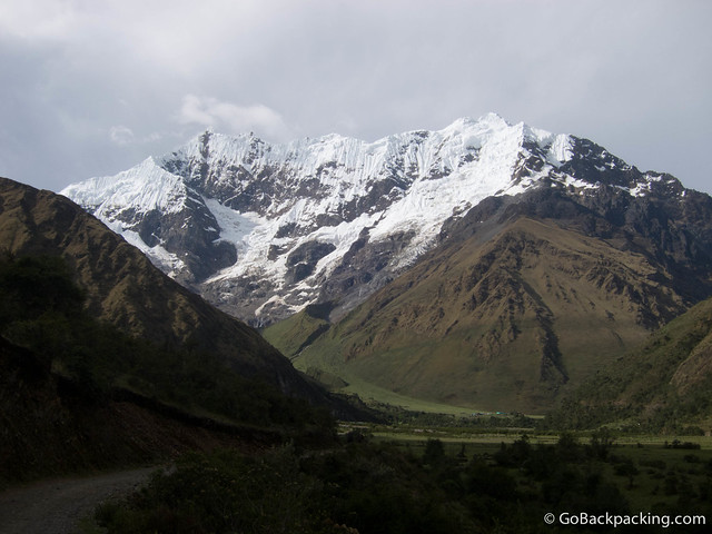
The highlight of the 4-day Salkantay Trek to Machu Picchu is the opportunity to walk in the shadow of the snow-capped Salkantay Mountain (6,264 meters). Unlike the classic 3-day Inca Trail trek, which requires you to book a spot at least five to six weeks in advance (in the low season), the Salkantay Trek can be booked in Cusco upon arrival.

And it can be done for less than half the cost. I'll be writing more about how to book the trek and what to pack in future posts. But first, I want to take you through the journey day by day, as it was an authentic outdoor adventure that tested both my mental and physical resolve.
Table of Contents
Day 1 - Cusco to Soraypampa
Begin: Mollepata 2,900 meters / 9,514 feet; End: Soraypampa 3,900 meters / 12,795 feet.
Change in Elevation: 1,000 meters / 3,281 feet.
Time walking: 5 hours 15 minutes
Pick-up
Awake at 4 AM, I wiped the sleep from my eyes, rolled out of bed, and moved my bags to the hostel reception. As expected, the minivan didn't arrive until 4:30 - 4:40 AM. Under the cover of darkness, we drove around, picking up additional trekkers. Our group for the next five days was slowly forming.
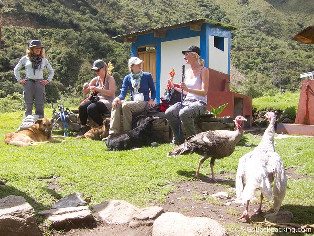
Abhishek, a young British doctor. A young German doctor. Two Dutch girls. Nicole (Canada). Two Malaysian women in their 40's. A young Japanese guy. And Kathy, an older Australian woman who had just completed the Inca Trail the day before (she did the two treks back to back).
Breakfast
As we drove from Cusco to Mollepata, a small pueblo, the sky began to brighten. We had a simple breakfast of bread and eggs with mate de coca (coca tea). Afterward, we were led to a large truck and hitched a ride for several kilometers up a steep, muddy road.
Our guide would say it saved us a few hours of walking, but nobody protested. Once the truck dropped us off, we began our walk straight up the mountainside.
Related: How To Get To Machu Picchu
I had given myself five nights to acclimate in Cusco, which is 3,300 meters above sea level, but I had failed to exercise then. My heart was pounding within the first few minutes.
One of the Malaysian women, both of whom had been to Everest Base Camp and successfully climbed Mt. Kilimanjaro two years earlier, complained of a headache. I knew if she felt bad at 3,100 meters before we'd even started, it wouldn't bode well for her that night or on Day 2, the most challenging day.
The sun was beating down and hotter than I'd expected. Covered in a familiar layer of suntan spray and mosquito repellent, I tried to settle into a comfortable walking rhythm. Over three years had passed since my last high-altitude trek to Indrahar Pass in northern India, and I hadn't realized it'd been so long since I'd given myself a good physical challenge.
Doubts began creeping into my head. They were familiar ones about my health at high altitudes and physical stamina. I recognized them from my Annapurna Sanctuary trek in Nepal, during which I didn't reach Base Camp, an experience that took me months to reconcile.
Lunch
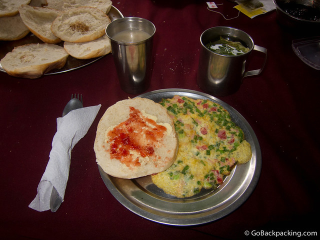
After two and a half hours of walking, we stopped for lunch: soup and a rustic version of lomo saltado (beef, vegetables, and rice). Despite knowing that food is energy, I barely finished half my plate and needed as much as possible. Instead, I relied on chocolate and copious amounts of water.
I probably drank two to three times more water throughout the trek and pissed two to three times more often than anyone else in our group.
Sitting at the table, mind filled with doubts about whether I was fit for this trek, one of the Dutch girls said something that snapped me back into reality. Paraphrasing, she said any of us could do this trek if we wanted it. And I wanted it badly.
From that point forward, I walked with renewed vigor-as if I'd been asleep at the wheel those first few hours and was suddenly awake. Instead of allowing my thoughts to run wild with fear, I took control of my mind, and thus, my body followed suit.
Campsite
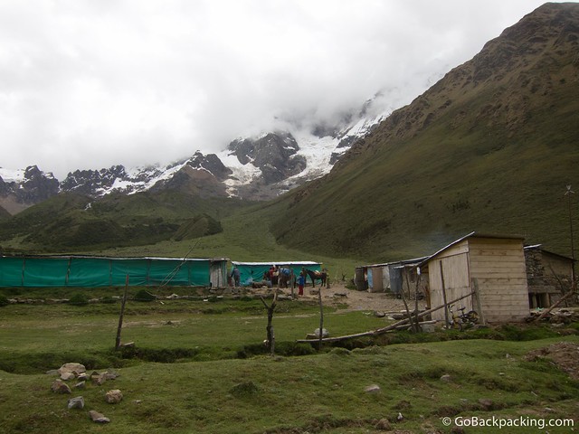
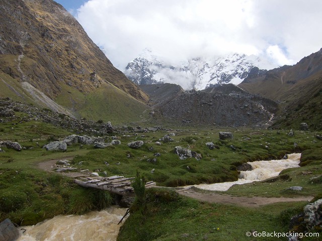
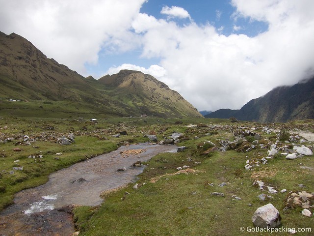
After lunch, we looked up the valley to see the glacier-covered Umantay. Unlike some trekkers, I gain energy by seeing the next camp -- the next destination. Almost two hours later, I walked into our campsite for the night.
We helped the cook and horseman pitch the tents in an area protected by a sheet metal roof and plastic tarp walls. It wasn't much, but it'd help keep the wind out and keep us dry if it rained. It was my first time sleeping at an altitude as high as 3,900 meters (12,795 feet).
We all scarfed down the popcorn served as an appetizer. I forgot the main course, but it was much better than lunch, as was the case with the meals on the remainder of the trek. By 10 PM, we were all in our sleeping bags. Day 2 would be the longest and most challenging trekking day, and we'd be getting an early start.
I woke up once in the middle of the night to pee. On the walk back to the tented area, I stopped and turned off my headlamp-total darkness. I craned my neck and looked at the star-filled sky-the bright stars you only see when you physically remove yourself from the modern world.
Day 2 - Soraypampa to Chaullay
Begin: 3,900 meters / 12,795 feet; High Point: 4,650 m / 15,256 ft; End: 2,900 m / 9,514 ft.
Change in Elevation: +750 m / +2,461 ft uphill, followed by -1,750 m / 5,741 ft downhill.
Time walking: 8 hours 15 minutes
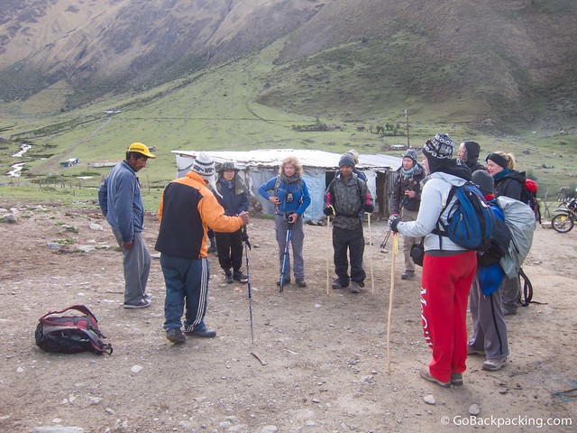
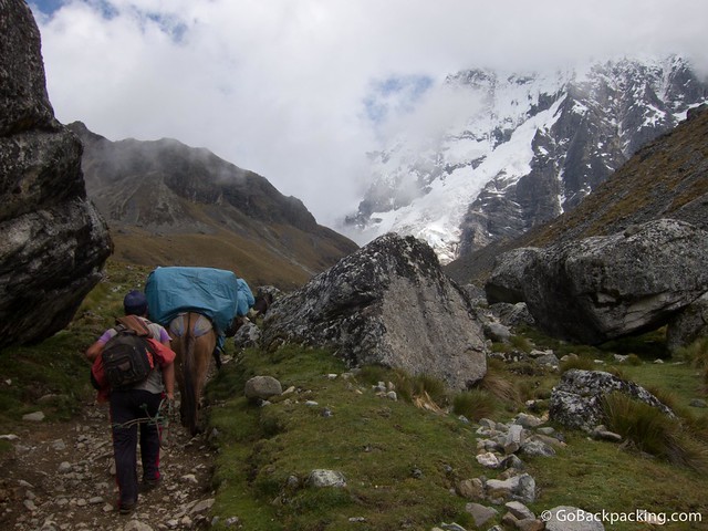
Day 2 started with a 5 AM wake-up call and a cup of coca tea. By the time we'd eaten breakfast, the sun was already reflecting brightly off the glaciers around us. Our guide, Daniel, took a few minutes to introduce the support crew, including a cook, assistant cook, and horseman who managed the horses that carried our camping equipment, food, gas, and supplies.
I had a relatively good night's sleep. It wasn't the most comfortable, as the sleeping mat was paper-thin, but my rented sleeping bag was sufficiently warm, which mattered most. I bought some extra chocolate and water. I think I walked out of camp with 3.25 liters of water in my bag, if not a little more.
Ascent
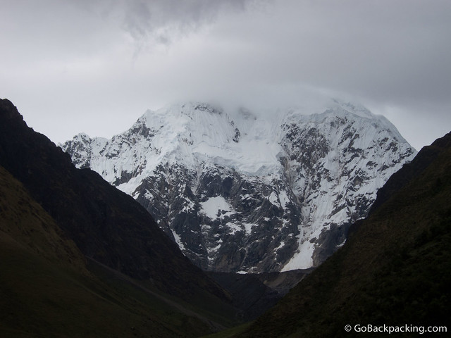
We began going up the valley toward Salkantay Mountain, which would remain partly shrouded in clouds the whole morning. The day before, we got a glimpse of the peak both on the drive to Mollepata and from Camp 1, which was enough to satisfy me, given we were there in the off-season.
Kathy, the Australian woman, shared some coca leaves with us and a natural "accelerator" that speeds up the effects when combined with the leaves. Within a minute or two of chewing on the leaves, the right side of my tongue went numb. Spitting out the juices, as if I were chewing on tobacco, was less than appealing, so eventually, I spit out the whole wad of masticated leaves.
Refocusing on the trail, the views continued to get prettier and prettier as our hearts beat harder and harder. But I loved every minute. It was as if I was running on pure adrenaline that morning. I've never felt so healthy and vital. I attributed this feeling to drinking tons of water and snarfing Snickers bars.
The Japanese guy outpaced us all, and we eventually lost sight of him. Meanwhile, the Malaysian woman with the headache from the day before had rented a horse to ride up the mountain pass that morning.
She had only spent two nights in Cusco before starting the trek, so her body had not had enough time to acclimatize. I don't blame her for renting the horse; I would've done the same if I felt it was in the best interest of my health. However, hearing at least one other person in the group make disparaging remarks annoyed me.
The High Point
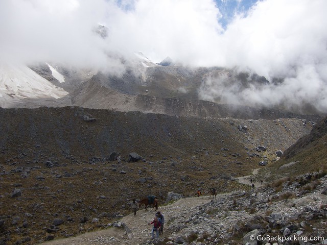
The closer we got to the 4,650-meter mountain pass, the more energized I felt. I surprised myself in the best possible way. The landscape had changed dramatically in the 750 meters we'd climbed in elevation. Gone were the green grasses, replaced by the rocky, moon-like landscapes often seen above 4,000 meters.
On Day 1, we practically had the trail to ourselves aside from a couple trekking with a guide. On Day 2, we shared the trail with that couple and another small group of trekkers. The lack of other people was a surprise and a clear benefit to trekking in the low season.
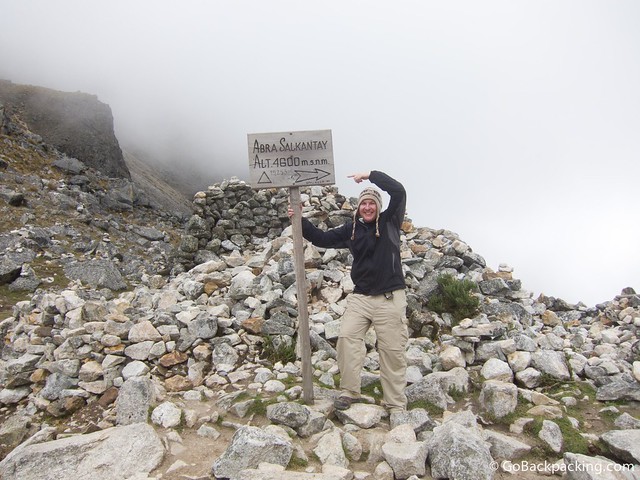
Euphoria struck us all as we posed by the sign marking the trail's high point. It was a new personal high for me in trekking at high altitudes, though I'd previously been as high as 5,000 meters during the visit to Pastoruri Glacier.
Maybe it was the thin air, but I felt I had the energy to go even higher. After three and a half hours of walking to the pass, I knew I could've gone even higher that day. But the most challenging part of the day wasn't going up; it was the following five hours it took to descend 1,750 meters in elevation.
Descent
After about 20 minutes of rest and picture-taking at the pass, we began our descent. Driven to reach a lower elevation to negate the ill effects of the altitude, I walked as quickly as my body would take me. My knees didn't appreciate that approach, and within a few hours, I started feeling sharp pangs of pain.
At an elevation of 4,000 meters in a verdant green valley, we stopped for a spaghetti lunch at the small village of Huayracpampa. Here, we found the Japanese guy sleeping on our bags, which had been unloaded from the horses upon arrival (ahead of us).
The last three hours of walking were the killer. Physically, they were the most challenging part of the trek for me. I slowed my pace and adjusted my walking style on the steeper bits. The whole trail was scree and loose rock, like a dry riverbed. I wanted nothing more than to get to Camp 2 to lay down and rest.
I began repeating a mantra, "You can walk slowly, but you must keep walking."
Blisters
When we finally arrived in Chaullay, and I removed my shoes and socks, I was greeted by four to five painful blisters on each foot. I usually carry a sewing needle to drain them, but I'd forgotten. Luckily, the German girl had one to spare. Dinner was a relaxed affair, and I went straight to sleep after it was over.
Day 3 - Chaullay to Santa Teresa
Begin: 2,900 m / 9,514 ft; End: 1,900 m / 6,234 ft.
Change in Elevation: -1,000 m / 3,281 ft.
Time walking: 4 hours 15 minutes
It rained at some point during our second night as we awoke to wet tents. However, I slept like a log. Even though we were 1,000 meters lower than the first night, the temperatures were far warmer than we'd experienced at Camp 1.
Rising around 6 AM to coca tea delivered to our tents, we had a filling breakfast, said goodbye to our horseman and horses, and walked along a dirt road that follows the Lluskamayu River. A recent landslide had taken out a section of the regular hiking trail, which runs on the opposite side of the river, so we took a detour for safety reasons.

Setting the Pace
Reinvigorated after a whole night's rest, I lead the pack. Compared to the first two days of walking, Day 3 was a breeze. We followed the river for the entire day's walk. As we descended in elevation and the sun rose higher in the sky, it became very hot and humid.
I walked quickly simply because I wanted to reach our camp for the night and escape the heat. It didn't take long for my knees to reject this strategy. Once again, I was feeling sharp, at times crippling, pains in my knees.
Landslides
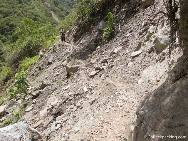
We could detour around one massive landslide that affected the trail, but others still required us to pass them. It helps if you don't look down. A little over four hours after we started, we reached the trail's end.
A minivan was waiting to take us the short distance to the village of Sahuayacu (elev: 2,520 meters), where we had a gigantic lunch of soup, fried rice, and vegetables. We then hopped back into the van to drive to nearby Santa Teresa, where we would spend our third night.

The reward for getting this far was a dip in the hot springs outside Santa Teresa. They're situated in a scenic spot alongside the river, and we arrived before the other groups doing the Inca Trail and Inca Jungle treks. For 10-15 minutes, aside from a few locals, we had the pools to ourselves.
That night, we were to have a campfire. However, heavy rain washed those plans away. Instead, we drank beer and played a few rounds of a card game (called asshole) after dinner.
Day 4 - Santa Teresa to Aguas Calientes
Begin: 1,900 m / 6,562 ft End: 2,000 m / ft.
Change in Elevation: -100 m / 328 ft.
Time walking: 3 hours
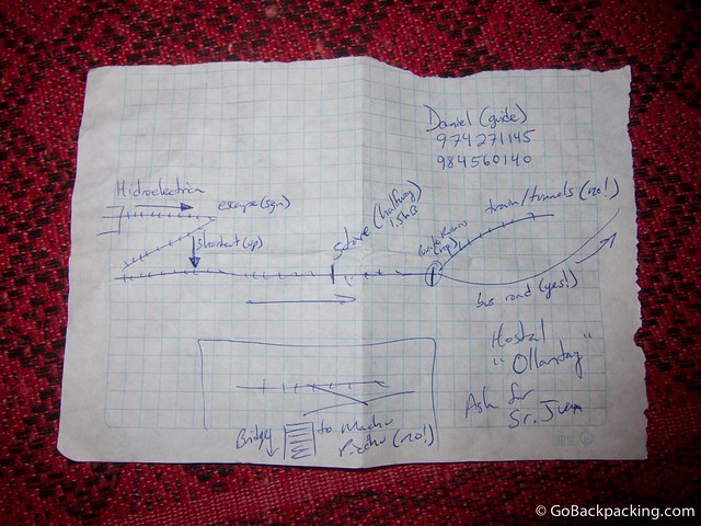
On the fourth morning, the group split up. I wanted to head straight for Aguas Calientes, as did Nicole (Canada), while the rest of the group wanted to pay about $30 to ride what's billed as South America's biggest zipline. Daniel drew Nicole and me a map from the Hydroelectric plant to Aguas Calientes. It was as if we were in Stand by Me.
Walking the Train Tracks
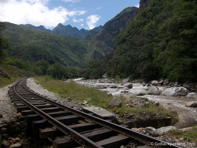
Nicole and I took a 30-minute taxi, along with an Argentinian trekker, to the start of the railway that runs from the Hydroelectric plant through Aguas Calientes and Ollantaytambo to Cusco. There were still sections where we had to walk on the loose rock of the railroad tracks. However, it was a flat walk through the valley behind Machu Picchu. Along the way, a dog began to follow us. Daniel informed us that the trains pass every hour or two, and sure enough, we had to step aside for one during the 3-hour walk.
Aguas Calientes
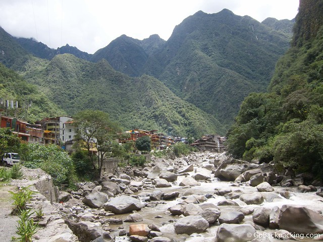
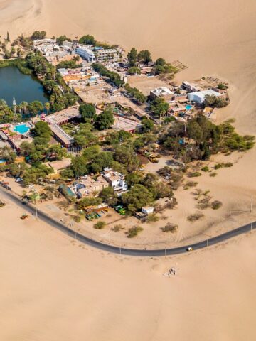
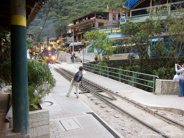
When we reached the entrance to Machu Picchu, near the train tracks, Nicole and I posed for pictures since we'd get up before dawn the next day to hike up. With excitement and relief, we finally walked up to the road from Machu Picchu's main entrance to the town of Aguas Calientes. Situated along the river, with the train tracks running straight through the center, it's a tourist town in the strictest sense of the term.
Upon finding our hostel for the night, I showered and treated myself to a one-hour massage, followed by coffee and a piece of rich chocolate cake. Dear civilization, I missed you! That night, we had a group dinner at one of the restaurants. We all ordered the trucha (trout), a dish I've come to relish when up in the Andes.
After dinner, a few of us went for a cocktail - five for one caipirinha, which drew us in the door. Unfortunately, they were the tiniest cocktails I'd ever been served. And we forgot about the inevitable tax and service charge they'd tack on.
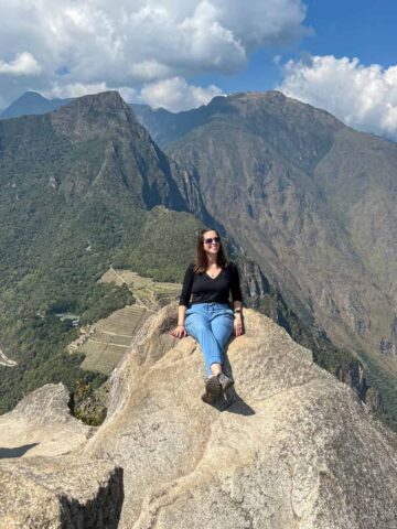
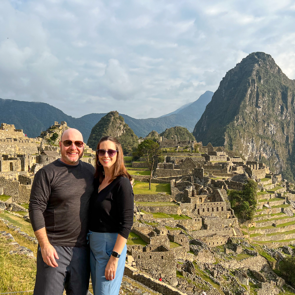
Small drinks aside, it was nice to spend a little time bonding before we set off for our final destination, Machu Picchu and Wayna Picchu, before dawn the following day.
***
Dave's 160-page, all-original Lima Travel Guide is available for Kindle.